

20 miles from Hailey, Muldoon mines offer glimpse into Idaho’s past
BY KAREN CROWSON
As early as the late 17th century, Spanish miners dotted the western portion of the United States, mining on small scales. But it was in 1848, with the discovery of gold in California, that the landscape of the West would change forever.
For the Idaho Territory, exploitation of silver and base metals (metals that aren’t gold and silver) marked the beginning of both the development of the Idaho Territory as well as Idaho’s mining industry.
The settlement of the Wood River Valley can be attributed to many of these early mining areas. One area in particular is the Wood River lead mines, which were discovered around 1881.
These early mines contributed vastly to the economy of Idaho and the nation, and in the upcoming years over 200 mining districts would be formed to extract both base and precious metals, such as copper, gold, lead, silver and zinc. It was during this time, when the majority of the mines were in operation, that silver was valued at around $1.10 per ounce and gold at $20 per ounce. Comparing these prices with today’s current prices shows the exceedingly high values of ore extracted from these early mines.
Situated in the Little Wood River region were the Muldoon Mine and the Idaho Muldoon Mine. These mines were associated with the Little Wood River Mining District that is now part of the Challis National Forest, located in the canyons of Muldoon Creek and Garfield in the Pioneer Mountains. The Muldoon Mine is located on the west side of the Muldoon Creek canyon and the Idaho Muldoon Mine is on the east side. The Muldoon Mine is less than three miles above the canyon’s mouth. It was here, at the mouth of the canyon, that the settlement of Muldoon was born.
Rich veins exposed on the surface attracted prospectors who then developed more mines. Built in 1881 to serve the mines of Muldoon and Argosy creeks, the Muldoon mMne progressed rapidly in production. There at the mouth of the canyon Muldoon began its birth, and by late 1882, two 50-ton smelters were situated at the canyon’s mouth and were capable of smelting, per smelter, 40 tons of ore per day. Just a year later the Muldoon Mine had produced around $345,000 worth of ore.
Once upon a time, the town of Muldoon consisted of livery stables, stores, a sawmill, saloons, homes, a hotel, post office, and schoolhouse, with a population of 1,500 at Muldoon’s prime. Another small settlement named Tustin also existed just three miles by road up the canyon.
During the early 20th century, the mines struggled to re-start since the close of the Muldoon Mine years before. The smelters were no longer accessible and the nearest smelter was the 26-mile wagon haul to Bellevue.
With the onset of WWII, interest in the Little Wood River Mining District grew and the Idaho Muldoon Mine was re-opened as well as the Eagle Bird in Garfield Canyon. The owner of the Idaho Muldoon Mine was T.U. Williams, who revamped the mine tunnel as well as sinking a 40-foot shaft 160 feet from the entrance of the tunnel. In 1943, the area saw several shipments of ore from these mines as well as mine tailings in August 1945.
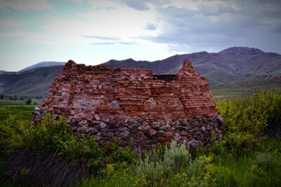
Today, little remains of the settlements Muldoon and Tustin, as well as the mines that once dotted the landscape. At Smelter Butte, only the remains of beehive kilns can still be seen. These kilns were used to create charcoal for smelting the ore and are shaped like a beehive or dome. They were designed this way so that the temperature could be controlled so as to end up with the right product. Still preserved today is the schoolhouse and post office, with the post office having been moved to a ranch on Copper Creek five miles below its prior location.
The rocky foundations and broken-down kilns stand as a reminder of the old days of the West, shadowing times long gone.
How to get there:
The former townsite of Muldoon can be reached by driving approximately 20 miles east of Bellevue on Muldoon Canyon Road, up and over Muldoon Summit and across the Little Wood River. Muldoon Road is not maintained in the wintertime. Another way to get there is to take Highway 20 east to Carey, and then out the Little Wood Reservoir Road. Exploring Muldoon in the summer and fall is recommended, as roads and weather in spring and winter can make traveling in this area difficult.