

Flood Preparations to Begin in Blaine County
By DANA DUGAN
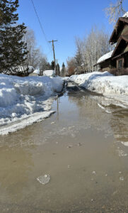
Floods will happen. The Wood River Valley has been here before, most recently in 2017. If you live, work or recreate near the Big Wood River, you will be affected. Blaine County, and its cities, are beginning to gear up for the snow melt-off in the Wood River Valley.
“We’re ramping up discussions, responsibilities and things that will be available,” Chris Corwin, Disaster Services Coordinator for Blaine County, said. “By April 1, we should be ready to go. Usually, the flooding is by the end of April, but there are variables with the weather. Ideally, most people are already aware if they’re in the 100-year floodplain, or the 500-year plain.”
Those floodplains are in areas in which analysis has already been established but there’s a common misconception with the FEMA floodplain mapping. Most people believe these will happen every 100 years. But historically, the data now shows that floods of this magnitude occur every nine to 10 years. The degree of flooding remains uncertain.
“2006 was a big one with similarities; we didn’t peak until April 16, but it burned off pretty quickly,” Corwin said.
Burning off refers to thermodynamics, or the relation between heat, work, and internal energy.
“It’s a little early to tell,” Corwin said. “But if you look at SNOTEL sites and [weather] stations, we can compare the years. Colorado Gulch is a good barometer as a SNOTEL site. The most recent flooding was 2017. We’d already reached max snow at March 7. We’re very close to where we were then. Another storm and we’ll be at the same place. The big burn-off began April 16, and by May 1 we were having issues.”
Hailey City Administrator Lisa Horowitz said the city will host two upcoming community meetings to let the community know “what the city will be doing and, most importantly, what it will not be doing. We’ll spell that out clearly, what they can expect from us.
“It’s not the cities so much as what comes out of the mountains, which will happen later, although people have already had issues with the rain/snow events on the roads and driveways.”
Corwin said the usual areas will be affected.
“War Eagle (in the Della View subdivision area of Hailey) is always tricky because it’s so low down in there. But at this point it’s just snow. There’s a spot where when it funnels down and pushes to the left. Della View will have a lot of water. On warm days, there will be water on Highway 75. Since the ground is still frozen, the water can’t go anywhere. One of the biggest things to know is if your home is prone to flooding. If you can do it financially, there are giant bladders.”
In Carey, “There is some concern for the houses along the river channels along the Little Wood River,” says Corwin.
FEMA flood insurance is available, but homeowners must begin that process at least a month prior to expected flooding.
Blaine County Floodplain Manager Kristine Hilt is working with FEMA on a long-range plan to update flood areas based on aerial photography from past events.
“First and foremost, know your flood risk,” Hilt said. “There are so many resources like inundating mapping to see what areas are affected. It’s not live yet. But you can reach out to us (at the county) for that information. We also have aerial imagery from previous events in 2006 and 2017. Those are available and people can see where the river went. It’s very accurate.”
Hilt said there are several important factors homeowners can do now. One is understanding access to your property.
“Your house may be safe, but what about your driveway or access for emergency services? What is the drainage around your neighborhood? People who live close to mountains will have snow coming off. Where will that water funnel into the neighborhoods?”
Hilt said that when the Big Wood floods, there can be a great deal of erosion, and river migration into certain neighborhoods.
“Second of all, call your insurance agents,” Hilt continued. “The FEMA flood program Risk Rating 2.0 is new in the past couple years. It’s a different approach to rating insurance policies. It doesn’t use flood zones as a rating factor. Instead, it uses distance from water, what kind of construction a house is, and other variables. This is a huge change.
“Know your regulations. Know where you can put sandbags and bladders. Get supplies ahead of time and be familiar with which people to call if there’s an issue, like Idaho Power and Intermountain Gas. If you’re at risk, store important documents, take photos or videos of items for insurance.”
Avalanches will also continue to be an issue. Only two weeks ago there were slides across the river, and up north across Highway 75, shutting it down north for several hours.
Sawtooth Avalanche Center issued this warning on their website: “Large, destructive, natural and human-triggered avalanches are almost certain to occur. Avoid all avalanche terrain. Stay off and out from below steep slopes—slopes steeper than about 30 degrees. Avalanches may be triggered remotely—from gentler terrain above, below, and to the sides of steep slopes.”
To find out if you are in a floodplain:
Visit https://www.co.blaine.id.us/
Click on
1. Government,
2. Departments GIS Mapping
3. Agree and Continue to Mapping Page
4. Water Information
5. Click on magnifying glass to search for your address