

BY DANA DUGAN
The 2,234-acre Stewart Creek Fire continues to burn 13 miles northwest of Fairfield, in Camas County, to the west of Blaine County. The fire was 37 percent contained as of Tuesday afternoon.
The fire was started by dry lightning on Monday, Aug. 20, in the Sawtooth National Forest. Weather conditions, dry fuels and rough terrain aided in the fire spread last week. Incident Commander Steve Goldman, of the Eastern Area Incident Management Team, has put crews at various spike camps to build fire lines where accessible, to help impede fire spread and guide the fire to the east and north.
The Bureau of Land Management ground is closed for public and firefighter safety. Nearly 4,000 acres of BLM-managed land is impacted by the closure that includes areas south of the national forest boundary and north of State of Idaho endowment lands in the Chimney Creek area north of Hill City. Chimney Creek Road has been closed off by Camas County.
“As fire crews are working in this area, it is important that members of the public avoid this portion of public land for the time being,” said Codie Martin, Shoshone field manager in a Friday news release.
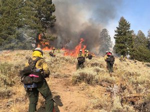
The fire is burning in standing timber and heavy downed and dead brush, with visible single-tree and group torching. The Eastern Area Incident Management Team took command of the fire on Aug. 31.
“Threatened structures include two cabins, big game habitat, recreation/trail areas, grazing allotments and cattle,” said Julie Thomas, public service officer for the Sawtooth National Forest.
Working the fire are 404 personnel from Oregon, Utah, Arizona and Alaska, as well as crews from Idaho.
Available air resources are being used in inaccessible and dangerous areas where firefighters are unable to safely operate due to extremely steep terrain or hazardous standing dead trees, also known as snags.
Similar dry weather conditions will continue this week. According to the Sawtooth National Forest, ground and air resources will continue firing operations, so expect to see more smoke and active use of aircraft. The resources on the southern part of the fire will continue to secure and strengthen indirect lines in anticipation of continued firing operations in the coming days.
The western portion of the fire will remain in a monitor status.
In the north, aircraft will continue to be used to slow the growth of the fire while still allowing the fire to advance towards the Soldier Mountains, where it will run into natural barriers, minimizing fire spread.
For more information, track the fire on Facebook at U.S. Forest Service-Sawtooth National Forest.
Closures and restrictions remain in the Fairfield Ranger District, Ketchum Ranger
District, Minidoka Ranger District and Sawtooth National Recreation Area, Sawtooth National Forest.
There is a Temporary Flight Restriction in effect for the fire area. This restriction includes the use of drones.
No fires may not be built or lit outside of Forest Service designated areas, and no smoking is permitted outside unless there is three feet of barren or cleared area surrounding the smoker.