

Tough Decisions To Evacuate
BY ISAIAH FRIZZELL
Nature is always in control. It’s bigger than we are and sometimes we have to work hard to coexist. The Wapiti Fire, which was started by lightning on the evening of July 24, 2024, nearly two miles southwest of Grandjean, on the Boise National Forest, continues to be a huge, ongoing battle.
What do you do in the event that your land and environment are in critical danger? For residents of Stanley and surrounding enclaves, many have had to make the tough decision to evacuate and potentially let go of homes and belongings.
 Rocky Mountain Incident Management (RMIM)
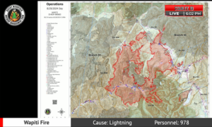
On August 29 the RMIM held a public meeting to discuss progress as many crews battle the fire over an area estimated at 89,714 acres. While the blaze remains a threat, much of it has been contained due to the perseverance and teamwork of all involved.
Operational Update
Operation Sections Chief Lance Martin gave a round-robin overview beginning in the southwest and moving clockwise around the Wapiti Fire.
• The Bear Creek summer home area is under heavy guard, but looks to be nearly under control.
• Near Warm Springs landing strip intakes new resources. The fire is still growing just north of the landing strip area in very rough terrain and the intent is to contain it north of High 21.
• The Seven Peaks and Sourdough area receives more resources with new crew and much hoses deployed in the north.
• The fire appears to be slowed by natural features farther north and into the Bull Trout Lake area. From Highway 21 to Bull Trout Lake, it was successfully contained toward Martin Lake.
• North toward Boy Scout, a number of crews are prepping along the road heading toward Boy Scout camp.
Resources are heavily deployed toward the northeast of the fire around Boy Scout camp in case the flow comes out of Hatcher and crosses Highway 21.
• Farther down the Highway 21 corridor, moving south toward Valley Creek, crews are set up to assess changes, such as a potential southerly wind, but the area is largely under control.
• On the east side of Highway 21 in Valley Creek, a large number of resources are doing structural assessment where all appears to be contained and well fortified.
Toward the Crooked Creek and Homestead areas, continuing southeast of the fire, the coming days will see heavy deployment of resources to burn out any potential hotspots.
The spot fire near lower Stanley, close to Nip and Tuck, is completely under control and with zero new growth the area is kempt.
• South toward the Iron Creek community, a successful burnout operation on Wednesday, August 28, shut out the fire. While it is possible the blaze could come back, crews are building a large buffer behind the Iron Creek community, working south toward where the Bench Lake Fire raged earlier this summer. Depending on weather, there is potential for the fire to burn down farther into the Sawtooths.
Weather
Incident Meteorologist Trainee Woody Unrue presented a General Weather outlook showing a number of critical conditions from Friday through Monday when it is projected weather threats should begin to decrease. As the high-pressure system dissipates, a low-pressure system should bring scattered precipitation on Monday. Dry and dangerous conditions return shortly after, however.
Behavior
Fire Behavior Analyst Glen Lewis spoke on the abundance of dry ‘fuels’ (anything that will burn) that helped the fire burn strong while efforts largely kept it in place. When heavy dry fuels come into alignment with a slope, the fire runs up the hill. Fire tends to flow like water, although somewhat in reverse, tending to run uphill. Fire at the top of a slope loses alignment and stops. Lewis describes a pulsing scenario as this fire ran up, down and jumped slopes in alignment with the weather and fuel. One of the biggest issues are flying embers, which can create adjacent hotspots.
Thursday and Friday saw hot, dry and windy weather, which heavily propagated the fire. By Saturday, August 24, favorable moisture helped slow the fire. By Monday, the drying out created movement in many large spots. Tuesday, the weather became near critical, coming out of the southwest pushing the blaze farther to the northeast. Many successful firing operations secured Highway 21 northwest of Stanley.
A spot that burned heavily across Highway 21, northwest of Stanley, was anticipated by a computer model. In a beautiful human success, prior to the model, the operations managers’ instincts had anticipated this spot. They were there, ready with a plan, a crew in place and put a line around it, keeping the hotspot steady in place.
A northwest wind change brought heavy, visible smoke and gave the fire some of its biggest pushes to grow toward the north and northeast while many spots took it farther.
The coming weather will produce more smoke and further grow the fire. The smoke itself, however, is somewhat of a mixed blessing as it lowers the temperature, much like cloud cover.
Smoke
Air Resource Advisor Amber Ortega espoused the need for smoke safety, pointing out that smoke intoxication is cumulative and leads from a slight cough or burning eyes to mental irritability and eventually cardiovascular damage. This can go unnoticed in the beginning stages.
You can readily get your area’s smoke forecast, from Boise to Salmon, through the Fire and Smoke map at www.fire.airnow.gov, which will geolocate to your area. A color-coded Air Quality Index will give you a scale to judge your oxygen availability. The hazardous category has dominated for the last few days and will remain so in Stanley. Monitors placed at the Lowman Ranger Station on Highway 21, the Sawtooth National Recreation Area Headquarters on Highway 75, and a new one at the Valley Springs spike camp feed accurate data on air quality.
It is highly recommended to limit the time you keep doors and windows open, especially if in a hazardous zone. Smoke can become trapped inside during these days, however, and it is crucial to let it out on any favorable days. Box fans with furnace filters strapped to the intake are recommended and can filter your home’s air dramatically.
Highways
Custer County Sheriff Levi Maydole explained that Highway 21 will remain closed indefinitely until further progress while Highway 75 is completely open with no intention of closing withstanding future spotting fires.
Maydole explained the ‘Ready, Set, Go’ status of all affected areas as Ready – ‘Prepare Now’; Set – ‘Be Alert’; Go – ‘Evacuate.’ Efforts have lifted Lower Stanley and Gateway communities from ‘Go’ to ‘Set.’ Stanley is in ‘Set.’ Casino Creek is in ‘Ready.’
Insurance
Bureau chief of the Idaho Department of Insurance (DOI) gave a breakdown of the best ways to keep abreast of any potential losses by updating your contact information with your insurance companies and having copies of as many policies as possible for everything you are concerned about losing. As the DOI holds all of the insurance companies licenses, it is best to contact them first to get the ball rolling. They can be reached at consumeraffairs@doi.idaho.gov or (208) 334-4250.
Closures & Values
After a big thank you from Stanley Mayor Steve Botti, agency representative Kirk Flannigan gave an update on the closure map. Closure starts at Hell Roaring Trailhead continuing west to Imogene Lake and across the Wilderness. The boundary trail is open, connecting to the Lowman area, butting up against the Nellie fire north up over Cape Horn and around the Salmon Challis Basin Creek back to Hell Roaring. A closure map can be found at https://inciweb.wildfire.gov/incident-information/idbof-wapiti-fire.
Rocky Mountain Incident Manager Justin Conrad closed the briefing by stating the two primary value objectives: the first being firefighter and public safety, with community property coming in at a big second.
Redfish Lake and Lodge are open while Bench Lake and Point Campground stay closed.
The Wapiti Fire has become national news and is currently the number one priority fire in the entire nation. Around 1200 firefighters are active along with 70 engines, including helicopters, scoopers, tankers and drones. As this is a values-driven (community property, woodland resources) situation, focus is on areas of high value within the massive fire’s path.
This is not a “Let it burn” situation.
Take care if driving near affected areas. A video of the meeting can be found at https://www.facebook.com/wapitifireinfo2024/videos/1674776573319640